Bryce Canyon National Park Travel Guide: Best Things to Do, Hikes & Tips
Everything you need to plan a trip to Bryce Canyon National Park, including my favorite hikes, the best viewpoints, photography locations, and places to stay.


All photographs are © Roaming the Southwest unless stated otherwise. Unauthorized reproduction or use is prohibited.
Bryce Canyon National Park in southern Utah is home to the largest concentration of hoodoos in the world. Despite its name, Bryce Canyon isn't actually a canyon, but a series of natural amphitheaters filled with thousands of colorful rock formations.
Some of the park's best overlooks are steps from the parking lot, but I highly recommend hiking below the rim to experience the hoodoos up close. Here's everything you need to plan your visit, including my favorite hikes, photography spots, scenic drives, and places to stay.
Quick Guide to Bryce Canyon National Park
Where Is Bryce Canyon National Park & How Do You Get There?
Bryce Canyon National Park is in southern Utah, approximately 80 miles northeast of Zion National Park. The entrance is just south of Bryce Canyon City along Utah Highway 63, off Scenic Byway 12.
I recommend having your own vehicle, especially if you're combining Bryce Canyon with Zion or Capitol Reef on a Utah road trip.
Closest Airports to Bryce Canyon National Park
Las Vegas and Salt Lake City generally offer the most flight options for visitors planning a longer Utah road trip.
Driving to Bryce Canyon
Bryce Canyon is easily accessible from Highway 12, making it a convenient stop between Zion and Capitol Reef.
Approximate driving times:
- Zion National Park (Springdale): 2 hours
- Kanab: 1.5 hours
- Capitol Reef National Park (Torrey): 2.5 hours
- Page, Arizona: 2.5–3 hours
- Moab: 4–4.5 hours
The park's scenic drive extends approximately 18 miles from the entrance to Rainbow Point.
Best Time to Visit Bryce Canyon National Park
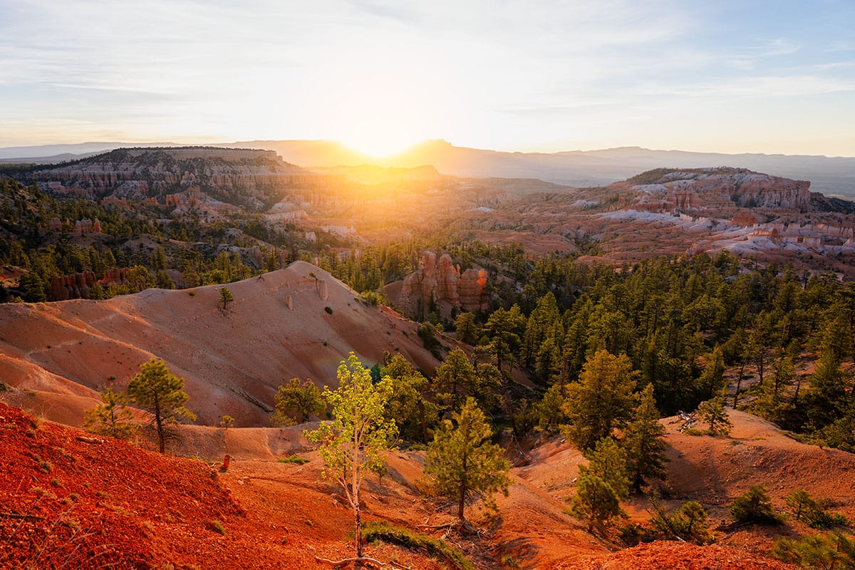
Bryce Canyon is open year-round, but its elevation makes it considerably cooler than other southern Utah National Parks. Winter is actually my favorite time to visit, especially for photography.
- Spring (March–May): Cold mornings, occasional snow, and potentially icy trails. May generally brings more comfortable hiking weather.
- Summer (June–August): Warmest and busiest season, although cooler than Zion. Start hikes early to avoid afternoon thunderstorms.
- Fall (September–November): Comfortable hiking temperatures in September and early October, with colder weather and possible snow later in the season.
- Winter (December–February): Snow-covered hoodoos are incredible for photography, but expect freezing temperatures, icy trails, and occasional road or trail closures. Microspikes are a must.
For more seasonal planning, see my Best Time to Visit Southern Utah and When NOT to Visit Southern Utah guides.
Bryce Canyon National Park Entrance Fees & Reservations
Bryce Canyon charges $35 per private vehicle, valid for seven days. The park also accepts the America the Beautiful Pass, which may save you money if you're visiting multiple National Parks. See my America the Beautiful Pass Guide for details.
Does Bryce Canyon Require Reservations?
No timed-entry reservations are currently required to visit Bryce Canyon. However, parking at popular viewpoints and trailheads can fill during busy periods.
Bryce Canyon Shuttle
Bryce Canyon operates a free seasonal shuttle included with park admission. It connects Bryce Canyon City with popular overlooks and trailheads, but the shuttle is not required to visit the park.
The shuttle doesn't serve the entire scenic drive, so you'll need your own vehicle to reach Rainbow Point.
Check current shuttle dates and hours before visiting.
Best Things to Do in Bryce Canyon National Park
Bryce Canyon has several overlooks accessible without hiking, but I highly recommend getting below the rim if you're able.
1. Hike Queen's Garden and Navajo Loop
My favorite hike in Bryce Canyon! This approximately 3-mile loop takes you down among the hoodoos.
I prefer starting at Sunrise Point via Queen's Garden and finishing at Sunset Point, hiking UP the Navajo Loop switchbacks. It's easier on my knees and less slippery than descending them. Follow the Rim Trail back to Sunrise Point to complete the loop.
The only time I reverse this route is when I'm photographing Thor's Hammer at sunrise.
Distance: 2.9 miles round trip
Difficulty: Moderate
Time: 2–3 hours
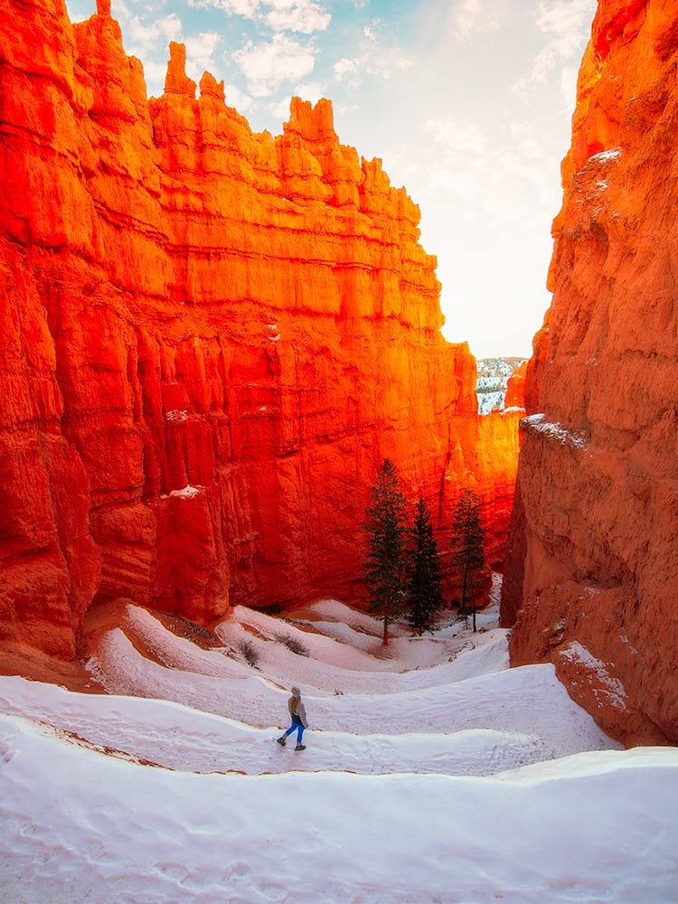
Important: Navajo Loop has two routes, Wall Street and Two Bridges, with separate sets of switchbacks. Wall Street closes seasonally during winter, so use Two Bridges when it's open and conditions allow.
2. Visit Sunrise Point
One of the best overlooks for early morning light and the starting point for the Queen's Garden Trail.
3. Visit Sunset Point and Photograph Thor's Hammer
Sunset Point overlooks Bryce Amphitheater and Thor's Hammer, one of my favorite sunrise photography locations. It's also the trailhead for Navajo Loop.
4. Stop at Inspiration Point
One of my favorite overlooks for panoramic views of Bryce Amphitheater, with three viewpoints along a short uphill walk. This is another great spot for sunrise.
5. Drive the Bryce Canyon Scenic Drive
The 18-mile scenic drive extends from the park entrance to Rainbow Point. My recommended stops include:
- Bryce Point: One of the best panoramic views of Bryce Amphitheater, looking down over thousands of hoodoos.
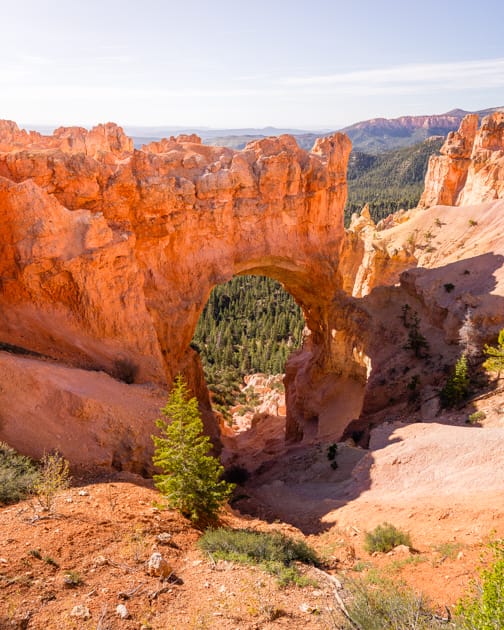
- Natural Bridge: A massive natural arch carved into the red rock, visible directly from the roadside overlook.
- Agua Canyon: Known for its distinctive hoodoo formations, including The Hunter and The Rabbit.
- Rainbow Point: The highest overlook along the scenic drive at 9,115 feet. It's also the trailhead for the 1-mile Bristlecone Loop, where you can see ancient bristlecone pines.
- Yovimpa Point: Sweeping views south across the Grand Staircase, with distant plateaus stretching toward the Grand Canyon.
Drive to Rainbow Point first, then stop at the overlooks on your return. Most will be on the right side of the road.
Allow: 2–3 hours with stops.
6. Hike Mossy Cave Trail
Located along Highway 12 outside the main park entrance, this short trail leads to a waterfall and mossy grotto. Water flow varies seasonally, and I've found the waterfall dry during summer and fall unless there's been recent rain.
Distance: 0.8 mile round trip
Difficulty: Easy
Parking is limited. Only use designated spaces.
7. Hike the Peekaboo Loop
A more challenging hike through the hoodoos with frequent elevation changes. The trail is shared with guided horseback rides during the operating season. This is my second favorite hike in the park.
Distance: 5.5 miles round trip from Bryce Point
Difficulty: Strenuous
8. Stay for Sunrise, Sunset, or Stargazing
I recommend experiencing at least one sunrise or sunset in Bryce Canyon. The park also has excellent dark skies for stargazing.
If you're staying after dark, bring warm layers and a headlamp.
Best Hikes in Bryce Canyon National Park
Bryce Canyon has everything from short rim walks to strenuous hikes below the amphitheater. My favorite is Queen's Garden/Navajo Loop, but Peekaboo and Fairyland are great options for longer hikes.
Keep in mind: Most hikes below the rim require a significant climb back out, and the elevation can make them more challenging than expected, especially if you're not used to hiking at high elevation. Check current trail conditions for seasonal closures, snow, and ice.
Best Photography Spots in Bryce Canyon National Park
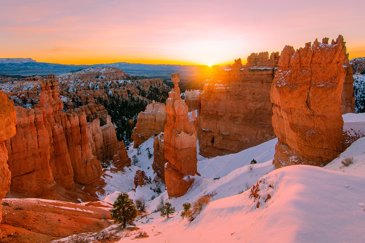
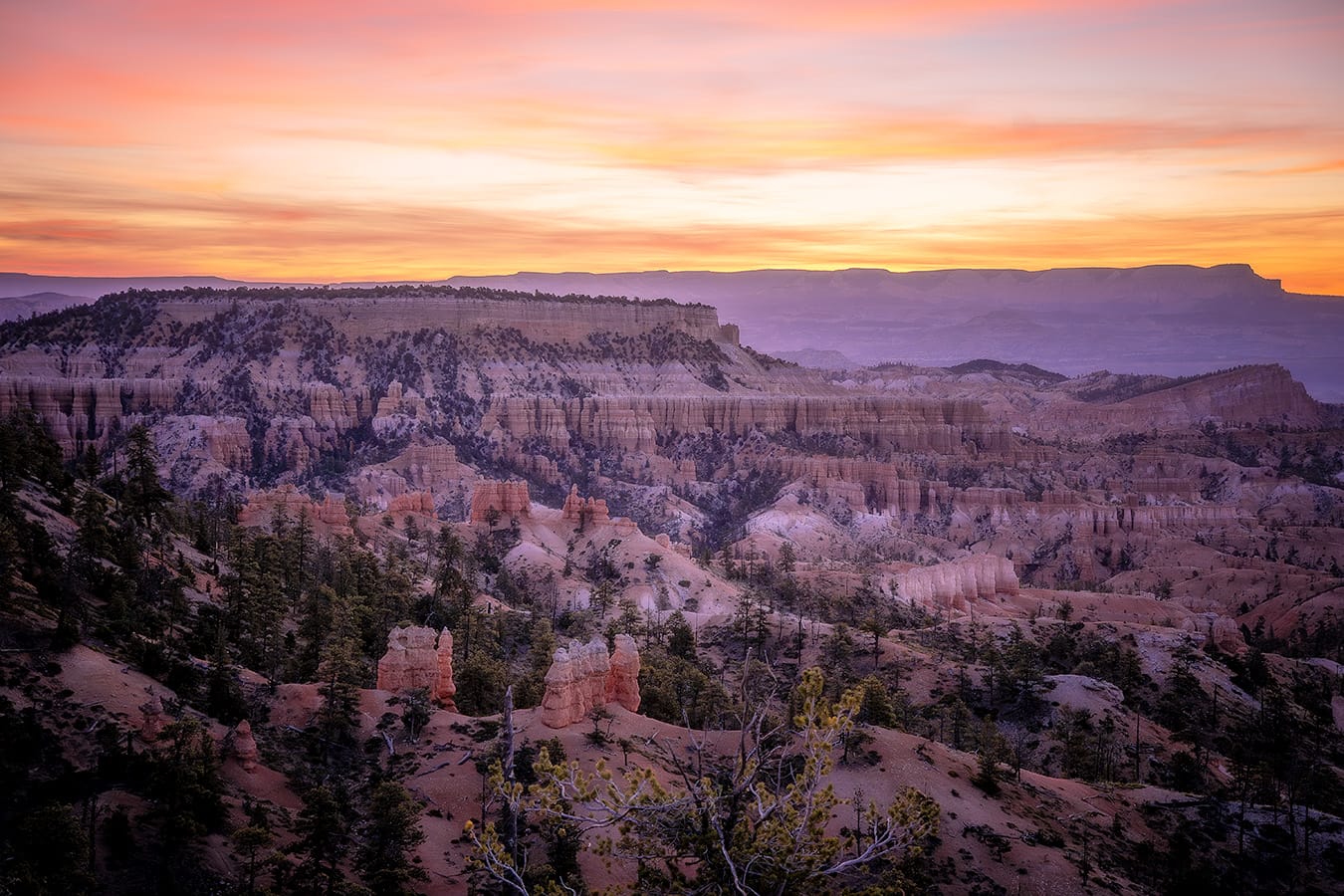
Bryce Canyon is one of my favorite places to photograph sunrise, especially after a snowfall. Many of the best photography spots are accessible directly from the rim.
A wide-angle lens works well for the amphitheater and switchbacks, while a telephoto lens is great for isolating individual hoodoos and layers of formations.
In winter, bring microspikes and be cautious around icy overlooks and trail edges.
Photographing Thor's Hammer at Sunrise
Thor's Hammer, just below Sunset Point, is one of my favorite sunrise photography locations. If I'm photographing it, I'll start at Sunset Point rather than taking my usual Queen's Garden-first hiking route.
Photographing the Navajo Loop Switchbacks
The Navajo Loop switchbacks are another favorite photography spot, especially from above. Both Wall Street and Two Bridges offer great compositions, but Wall Street closes seasonally during winter. I feel like the Two Bridges switchbacks are the ones most commonly photographed.
I prefer shooting the switchbacks between 16–24mm.
Bryce Canyon National Park Itineraries
You can see Bryce Canyon's highlights in one day, but two days gives you more time for hiking, photography, and the scenic drive.
One Day in Bryce Canyon National Park
- Sunrise: Sunrise Point or Sunset Point for Thor's Hammer photography.
- Morning: Hike Queen's Garden/Navajo Loop (2–3 hours).
- Midday: Visit Inspiration Point and Bryce Point.
- Afternoon: Drive to Rainbow Point, stopping at Natural Bridge and Agua Canyon on your return.
- Dinner: Ruby's Inn. I seriously crave their salad bar!
Two Days in Bryce Canyon National Park
Day 1: Bryce Amphitheater
- Sunrise at Sunset Point or Sunrise Point
- Queen's Garden/Navajo Loop
- Inspiration Point and Bryce Point
- Sunset photography and dinner at Ruby's Inn
Day 2: Scenic Drive and Additional Hiking
- Bryce Canyon Scenic Drive to Rainbow Point
- Peekaboo Loop or another hike
- Mossy Cave Trail along Highway 12
- Stargazing if you're staying another night
Bryce Canyon also fits perfectly between Zion and Capitol Reef on a 7-Day Utah National Parks Road Trip.
Where to Stay Near Bryce Canyon National Park
I've personally stayed at all three of these properties near Bryce Canyon National Park and recommend each of them depending on what you are looking for.
Ruby's Inn in Bryce Canyon City
One of my favorite places to stay AND eat near Bryce Canyon. I seriously crave their salad bar, and we'll make a detour to eat here anytime we're remotely close.
It's also just outside the park entrance, making it convenient for sunrise photography and early hikes.
Bryce Canyon Log Cabins / Happy Trails in Tropic
Bryce Canyon Log Cabins / Happy Trails
This is usually where I stay when visiting Tropic. It's a quieter alternative to Bryce Canyon City and convenient if you're continuing east along Highway 12.
Clear Sky Resorts in Cannonville
I've stayed in one of their stargazing domes, and it's such a unique alternative to a traditional hotel!
You can watch my video of our stay here.
Camping in Bryce Canyon National Park
Bryce Canyon has two developed campgrounds: North Campground, generally open year-round, and Sunset Campground, which operates seasonally.
Check the National Park Service camping page for reservations and availability.
Things to Know Before Visiting Bryce Canyon National Park
High Elevation and Cold Temperatures
Bryce Canyon sits above 8,000 feet, making it considerably cooler than Zion, even in summer. Bring layers, especially for sunrise, and expect hikes below the rim to feel harder at this elevation.
Be Prepared for Snow and Ice
Snow and ice are possible from fall through spring, and some trails close seasonally, including Wall Street during winter.
I've used Kahtoola MICROspikes for years and prefer them over cheaper coil-style traction devices. Always check trail conditions and closures before hiking.
Download Offline Maps
Cell service can be unreliable, especially along Highway 12 between Bryce Canyon and Capitol Reef. Download maps before leaving town.
Dogs Are Not Allowed on Most Hiking Trails
Dogs are permitted in certain developed areas and on designated paved paths, including the paved Rim Trail between Sunrise Point and Sunset Point. They're not allowed on trails descending into Bryce Amphitheater. Keep pets leashed.
Accessible Viewpoints
Sunrise Point, Sunset Point, and other overlooks offer accessible viewing areas without hiking below the rim. Accessibility may be affected by snow and ice.
Stay on Designated Trails
Bryce Canyon's hoodoos and slopes are fragile. Stay on established trails, don't shortcut switchbacks or climb formations, and use caution near unprotected cliff edges.
Frequently Asked Questions About Bryce Canyon National Park
Is One Day Enough for Bryce Canyon National Park?
Yes! One day is enough to visit the main overlooks, hike Queen's Garden/Navajo Loop, and drive the scenic road. I'd recommend two days if you want to do longer hikes or spend more time photographing the park.
Do You Need Reservations for Bryce Canyon National Park?
No timed-entry reservations are required. You'll need to pay the entrance fee or have a valid park pass. Campground reservations may be required.
Can You Visit Bryce Canyon Without Hiking?
Absolutely! Sunrise Point, Sunset Point, Inspiration Point, Bryce Point, and several scenic drive overlooks offer incredible views with little walking required.
Is Bryce Canyon Kid-Friendly?
Yes! Mossy Cave and the paved Rim Trail between Sunrise Point and Sunset Point are great shorter options. Queen's Garden/Navajo Loop is also an option for kids comfortable with the distance and elevation gain.
Keep children close around unprotected cliff edges.
Is Bryce Canyon Worth Visiting in Winter?
Absolutely! Winter is my favorite time to visit Bryce Canyon, especially for photography. Snow-covered hoodoos are incredible, and crowds are generally smaller.
Just be prepared for extreme cold, icy trails, and possible closures. The coldest morning I've ever experienced in Utah was photographing sunrise at Bryce Canyon after a snowfall, with temperatures below 0°F. Bring microspikes!
Can You Visit Bryce Canyon and Zion in One Day?
Yes, but I don't recommend trying to fully explore both parks in one day. They're approximately two hours apart, and while Bryce Canyon is easy to visit in a day, I'd give each park its own day if possible.
Planning a Southwest Road Trip?
Bryce Canyon is an excellent stop on a southern Utah road trip, especially if you're visiting Zion, Capitol Reef, and the other Utah National Parks.
These guides will help you plan the rest of your trip:
For even more help planning, check out my Best of the Southwest Travel Guide, featuring 350+ personally vetted locations and seven pre-built road trips throughout the Southwest.
Use code ROAM15 for 15% off.